The Complete Guide to the Kampung Sungai Baru Redevelopment Issue
timer
6 minutes read
October 10, 2025
The Kampung Sungai Baru redevelopment has been one of the most discussed urban renewal projects in Kuala Lumpur — not only because of its location next to Kampung Baru, but also due to ongoing debates about ownership, compensation, and land status.
Recent claims alleging that the developer is linked to a Singapore-based company and that Kampung Sungai Baru sits within Kampung Baru’s Malay Agricultural Settlement (MAS) have reignited public attention. However, both historical records and official verifications paint a clearer picture.
Following public concern, the government confirmed — based on checks with the Companies Commission of Malaysia (SSM) — that the developer involved in the Kampung Sungai Baru redevelopment is a Malaysian-registered company with no Singapore-based ownership.
This clarification effectively debunks viral allegations that a foreign-linked entity controls the project.
The redevelopment was approved through the Federal Territories Department (JWP) and is governed under Malaysia’s national redevelopment policies, not foreign ownership frameworks.
To understand the current debate, one must look back before the area even existed.
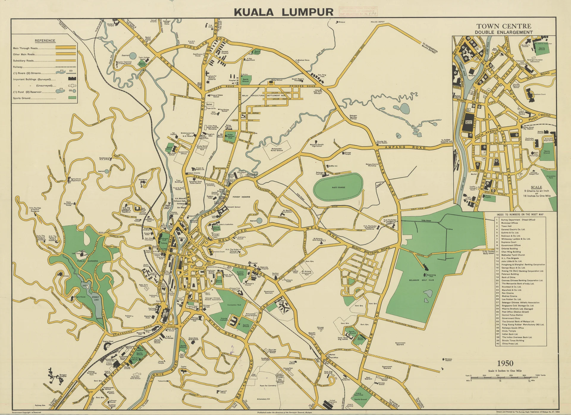
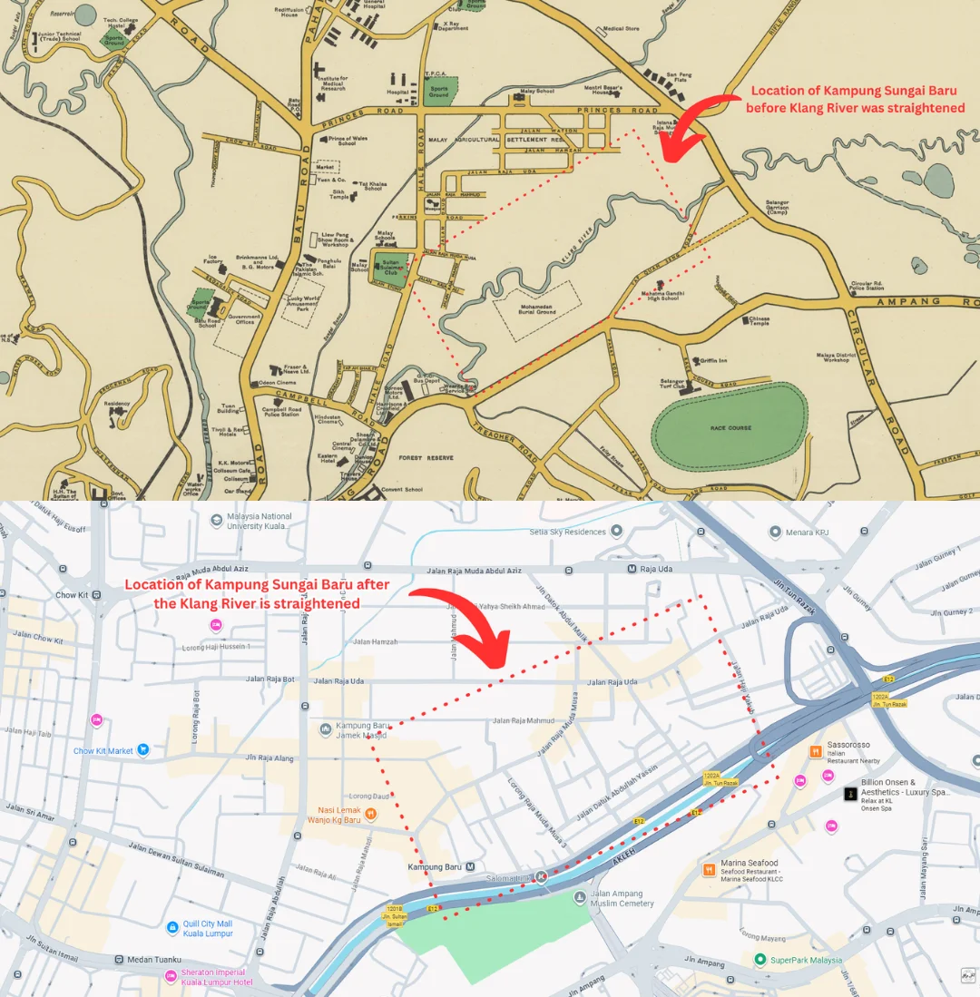
Based on land survey maps from the Survey Department of the Federation of Malaya (1950), the Klang River originally curved northwards, covering the area where Kampung Sungai Baru stands today.
[View file].webp)(1950 Kuala Lumpur Land Survey map - Survey Dept, Federation of Malaya)
The Kampung Baru settlement boundary, gazetted under the 1899 MAS enactment, extended only up to the right bank of the Klang River. This means that, prior to 1967, no land existed on the opposite side — only river.
In 1967, the government carried out a major river straightening project to reduce flooding and improve urban drainage. This engineering work created a new strip of reclaimed land on the right bank — and it was on this new land that Kampung Sungai Baru eventually formed.
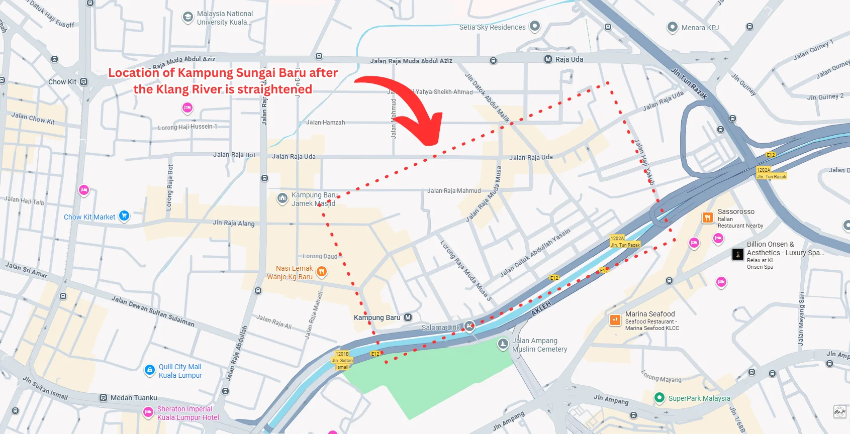 (2025 map showing straightened river and new land area)
The MAS (Malay Agricultural Settlement) area was created in 1899 specifically to safeguard Malay ownership within Kampung Baru. Its boundaries were legally defined by acreage and survey coordinates, not by riverbank changes decades later.
Since the land that became Kampung Sungai Baru did not exist during the MAS gazettement, it cannot be considered MAS land under any legal interpretation.
Some have argued that since the MAS boundary references “the right bank of the Klang River,” the newly reclaimed land should automatically fall within MAS. However, that logic contradicts the official recorded acreage — which has remained unchanged since 1899.
The Kampung Sungai Baru redevelopment is being carried out under the Federal Territories (Planning) Act 1982, involving the consolidation of multiple parcels of individually owned land.
The project covers approximately 13.5 acres and is aimed at replacing aging housing blocks (Flat PKNS and Flat Sungai Baru) and village homes with modern high-rise residences.
Affected owners are entitled to compensation in kind (new units) or cash payments, depending on their category and agreement.
Compensation has been one of the most sensitive points. Some owners have raised concerns over valuation differences and delays in disbursement.
However, the Federal Territories Land and Mines Office (PTGWP) and JWP have stated that the process follows existing land acquisition laws under the Land Acquisition Act 1960, which ensures compensation at market value.
In cases of disagreement, owners have the right to appeal the valuation through the High Court (Section 37 reference) — a process several owners have pursued.
In recent updates, the Court of Appeal upheld the legality of the government’s acquisition, confirming that the redevelopment process adhered to the law.
This decision effectively allows the project to proceed, though resettlement and compensation issues remain under negotiation between authorities and remaining affected owners.
The Kampung Sungai Baru debate illustrates the complex intersection between history, heritage, and urban transformation in Kuala Lumpur.
While Kampung Baru itself remains a protected MAS area, the existence of settlements like Kampung Sungai Baru shows how engineering projects — like river realignment — can reshape urban geography, leading to questions over what constitutes heritage land versus post-development expansion.
These maps visually demonstrate how the river’s alignment changed and how new land was formed, clarifying that Kampung Sungai Baru emerged after the MAS boundary was established.
The redevelopment is expected to continue in stages. Once complete, it is set to transform the area into a mixed-use residential development within walking distance of the Saloma Link and KLCC.
Authorities have reiterated that Malay ownership and resident priority will be maintained, consistent with the area’s cultural identity.
At MyRumahBaru, we see Kampung Sungai Baru as an example of how clarity in land classification and transparent communication can help bridge the trust gap between developers, residents, and the public.
For those who wish to understand earlier developments or compensation details, refer to our previous coverage:
🔗[Quick Facts: The Kampung Sungai Baru Redevelopment Issue in Kuala Lumpur]
🔗[Kampung Baru: Selangor Sultan Urges Careful Handling, Malay Interests Must Come First, Says Royal Office]
🔗[Kampung Sungai Baru Redevelopment: Owners to Receive Homes Worth RM884k to RM8.1m]
1. Is Kampung Sungai Baru part of Kampung Baru?
No. Historical maps show it was part of the Klang River until 1967. It only became land after the river was straightened.
2. Is Kampung Sungai Baru MAS land?
No. The MAS boundary was fixed in 1899 and does not include the reclaimed land that became Kampung Sungai Baru.
3. Who owns the Kampung Sungai Baru land now?
It consists of individual Malay landowners under freehold titles, governed by Malaysian land law — not MAS regulations.
4. Is the developer a Singapore-based company?
No. The government has verified through SSM that the developer is Malaysian-owned and registered locally.
5. Why did the government acquire the land?
The acquisition was for urban renewal under the Federal Territories (Planning) Act 1982 to redevelop old flats and improve infrastructure.
6. What compensation are residents receiving?
Compensation includes new replacement units or cash, based on valuation at market rate under the Land Acquisition Act 1960.
7. What happened to the residents who appealed?
Some appeals were heard in court. The Court of Appeal upheld the legality of the acquisition, allowing the project to continue.
8. Why is the river realignment important to this issue?
It proves the land didn’t exist during MAS gazettement. Kampung Sungai Baru formed only after the Klang River was straightened in 1967.
9. What’s the project’s current status?
The redevelopment is progressing after court clearance, with compensation and resettlement ongoing.
10. Why does this matter for other developments?
It sets an important precedent for how historically reclaimed or post-engineering lands are classified in relation to older settlements like MAS.
Recent claims alleging that the developer is linked to a Singapore-based company and that Kampung Sungai Baru sits within Kampung Baru’s Malay Agricultural Settlement (MAS) have reignited public attention. However, both historical records and official verifications paint a clearer picture.
1. What the Government Has Clarified
Following public concern, the government confirmed — based on checks with the Companies Commission of Malaysia (SSM) — that the developer involved in the Kampung Sungai Baru redevelopment is a Malaysian-registered company with no Singapore-based ownership.
This clarification effectively debunks viral allegations that a foreign-linked entity controls the project.
The redevelopment was approved through the Federal Territories Department (JWP) and is governed under Malaysia’s national redevelopment policies, not foreign ownership frameworks.
2. The Historical Formation of Kampung Sungai Baru
To understand the current debate, one must look back before the area even existed.
Based on land survey maps from the Survey Department of the Federation of Malaya (1950), the Klang River originally curved northwards, covering the area where Kampung Sungai Baru stands today.
[View file].webp)(1950 Kuala Lumpur Land Survey map - Survey Dept, Federation of Malaya)
The Kampung Baru settlement boundary, gazetted under the 1899 MAS enactment, extended only up to the right bank of the Klang River. This means that, prior to 1967, no land existed on the opposite side — only river.
In 1967, the government carried out a major river straightening project to reduce flooding and improve urban drainage. This engineering work created a new strip of reclaimed land on the right bank — and it was on this new land that Kampung Sungai Baru eventually formed.
3. Why Kampung Sungai Baru Is Not MAS Land
The MAS (Malay Agricultural Settlement) area was created in 1899 specifically to safeguard Malay ownership within Kampung Baru. Its boundaries were legally defined by acreage and survey coordinates, not by riverbank changes decades later.
Since the land that became Kampung Sungai Baru did not exist during the MAS gazettement, it cannot be considered MAS land under any legal interpretation.
Some have argued that since the MAS boundary references “the right bank of the Klang River,” the newly reclaimed land should automatically fall within MAS. However, that logic contradicts the official recorded acreage — which has remained unchanged since 1899.
4. The Redevelopment Plan
The Kampung Sungai Baru redevelopment is being carried out under the Federal Territories (Planning) Act 1982, involving the consolidation of multiple parcels of individually owned land.
The project covers approximately 13.5 acres and is aimed at replacing aging housing blocks (Flat PKNS and Flat Sungai Baru) and village homes with modern high-rise residences.
Affected owners are entitled to compensation in kind (new units) or cash payments, depending on their category and agreement.
5. Compensation and Disputes
Compensation has been one of the most sensitive points. Some owners have raised concerns over valuation differences and delays in disbursement.
However, the Federal Territories Land and Mines Office (PTGWP) and JWP have stated that the process follows existing land acquisition laws under the Land Acquisition Act 1960, which ensures compensation at market value.
In cases of disagreement, owners have the right to appeal the valuation through the High Court (Section 37 reference) — a process several owners have pursued.
6. Appeal Outcomes and Current Status
In recent updates, the Court of Appeal upheld the legality of the government’s acquisition, confirming that the redevelopment process adhered to the law.
This decision effectively allows the project to proceed, though resettlement and compensation issues remain under negotiation between authorities and remaining affected owners.
7. The Broader Significance
The Kampung Sungai Baru debate illustrates the complex intersection between history, heritage, and urban transformation in Kuala Lumpur.
While Kampung Baru itself remains a protected MAS area, the existence of settlements like Kampung Sungai Baru shows how engineering projects — like river realignment — can reshape urban geography, leading to questions over what constitutes heritage land versus post-development expansion.
8. Visual Evidence: The Changing Klang River
These maps visually demonstrate how the river’s alignment changed and how new land was formed, clarifying that Kampung Sungai Baru emerged after the MAS boundary was established.
9. What’s Next
The redevelopment is expected to continue in stages. Once complete, it is set to transform the area into a mixed-use residential development within walking distance of the Saloma Link and KLCC.
Authorities have reiterated that Malay ownership and resident priority will be maintained, consistent with the area’s cultural identity.
10. MyRumahBaru’s Take
At MyRumahBaru, we see Kampung Sungai Baru as an example of how clarity in land classification and transparent communication can help bridge the trust gap between developers, residents, and the public.
For those who wish to understand earlier developments or compensation details, refer to our previous coverage:
🔗[Quick Facts: The Kampung Sungai Baru Redevelopment Issue in Kuala Lumpur]
🔗[Kampung Baru: Selangor Sultan Urges Careful Handling, Malay Interests Must Come First, Says Royal Office]
🔗[Kampung Sungai Baru Redevelopment: Owners to Receive Homes Worth RM884k to RM8.1m]
FAQ (10 Comprehensive Answers)
1. Is Kampung Sungai Baru part of Kampung Baru?
No. Historical maps show it was part of the Klang River until 1967. It only became land after the river was straightened.
2. Is Kampung Sungai Baru MAS land?
No. The MAS boundary was fixed in 1899 and does not include the reclaimed land that became Kampung Sungai Baru.
3. Who owns the Kampung Sungai Baru land now?
It consists of individual Malay landowners under freehold titles, governed by Malaysian land law — not MAS regulations.
4. Is the developer a Singapore-based company?
No. The government has verified through SSM that the developer is Malaysian-owned and registered locally.
5. Why did the government acquire the land?
The acquisition was for urban renewal under the Federal Territories (Planning) Act 1982 to redevelop old flats and improve infrastructure.
6. What compensation are residents receiving?
Compensation includes new replacement units or cash, based on valuation at market rate under the Land Acquisition Act 1960.
7. What happened to the residents who appealed?
Some appeals were heard in court. The Court of Appeal upheld the legality of the acquisition, allowing the project to continue.
8. Why is the river realignment important to this issue?
It proves the land didn’t exist during MAS gazettement. Kampung Sungai Baru formed only after the Klang River was straightened in 1967.
9. What’s the project’s current status?
The redevelopment is progressing after court clearance, with compensation and resettlement ongoing.
10. Why does this matter for other developments?
It sets an important precedent for how historically reclaimed or post-engineering lands are classified in relation to older settlements like MAS.