New projects
Subsales
Rentals
New launch
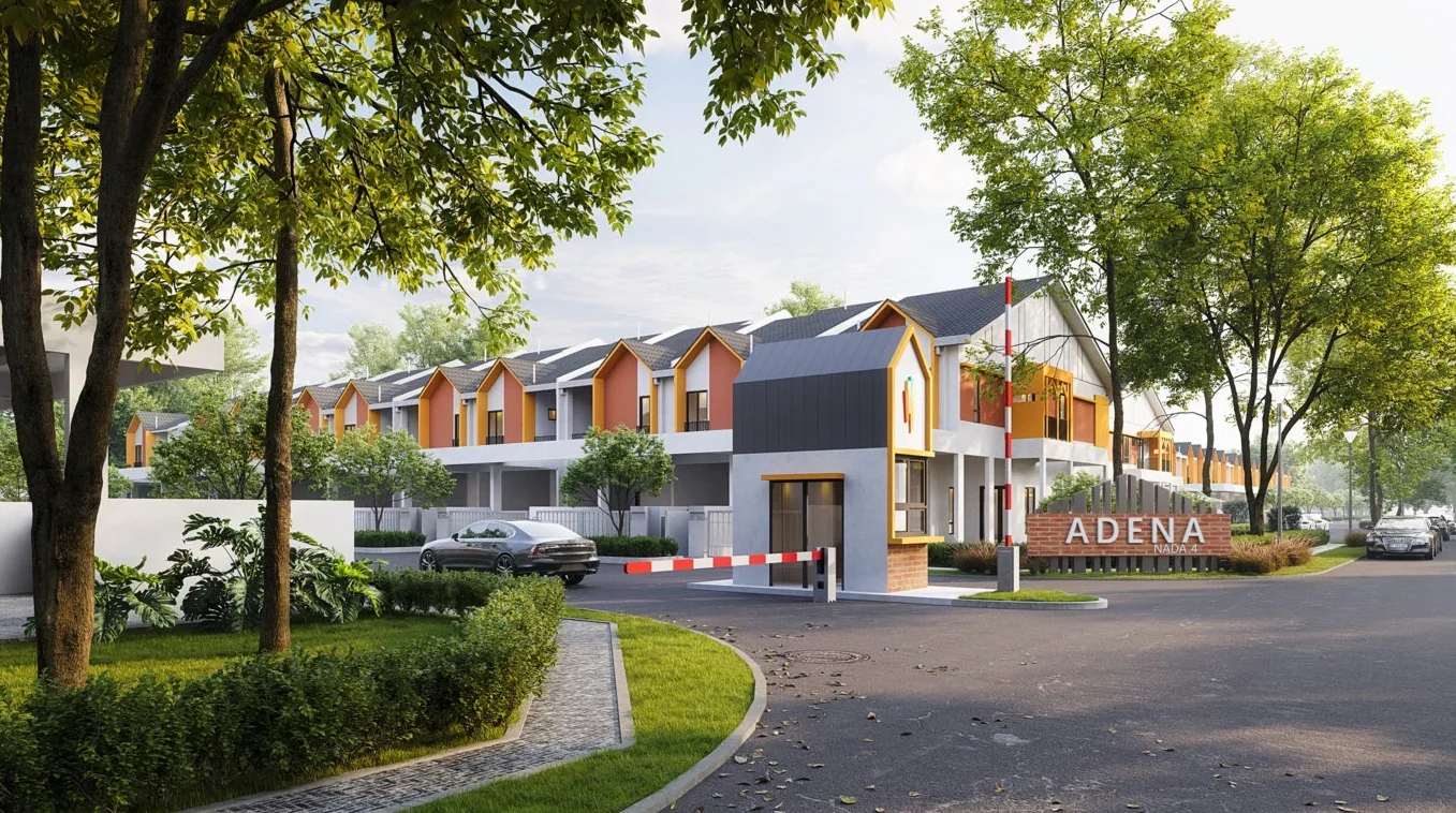
Adena @ Nada AlamNilai — for Sale
1 of 18
Price Range
SPA Price Before Rebate
RM780,000 - RM1,126,275
Bedroom

5
Bathroom

5
Completion
2026, Q2
Built-up
2,628 - 2,736 sqft
Get the latest offer for this project
Home details
Developer
Seri Pajam
Price per sqft
RM297 - RM412 psf
Title
Strata
Tenure
Freehold
Type
Terrace
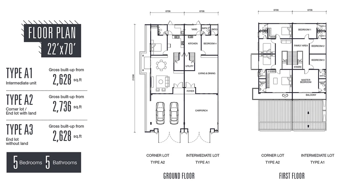
Layout size
2,628 sqft - 2,736 sqft
Unit layouts
Unit type
Type A1
Built-up size
2,628 sqft
Land size
22' × 70'
Bedrooms
5
Bathrooms
5
Carparks

2
Brochure
Sign in to view
Nearby points of interest
- school
Sekolah Kebangsaan Batang Benar
1.4 km
- school
SJK (T) Tun Sambanthan
1.7 km
- school
SMK Taman Semarak
2.9 km
- school
Kolej Tuanku Ja"afar Secondary School
3.2 km
- school
Sekolah Kebangsaan Kampung Kuala Pajam
3.7 km
- school
Sekolah Rendah Agama Kampung Kuala Pajam
4.0 km
- school
Sekolah Rendah Islam Tahfiz Darul Ulum Cawangan Nilai
5.2 km
- school
SMK Khir Johari
5.2 km
- school
SK Beranang
5.3 km
- school
PASTI Isbat Al Imtiyaz
5.4 km
1–5 of 10
Market intelligence
27 transactionsNADA 4 @ NADA ALAM · Seremban
RM 296.80 psf
This listing
-32.7%vs project median
RM 336
RM 441 (median)
RM 673
Cheapest in project
Most expensive
Median PSF
440.78
RM per sq.ft
Median price
873K
24-month median
PSF trend
-14.6%
12-month change
All transactions (last 3 years) · 53 total
| Price | Date | Built-up | PSF |
|---|---|---|---|
| RM702,000 | March 2026 | 1959 sqft | RM358.34 |
| RM702,000 | March 2026 | 1981 sqft | RM354.44 |
| RM891,000 | March 2026 | 2013 sqft | RM442.65 |
| RM747,000 | January 2026 | 1981 sqft | RM377.16 |
| RM891,000 | November 2025 | 1981 sqft | RM449.87 |
1–5 of 53
3-year growth
+2.6%
1-year growth
-14.6%
Median PSF (RM/sq ft)
Projects in Bandar Mantin Utama, Seremban · 10 projects
NADA 3 @ NADA ALAM
18 txns
RM449.36 psf • Freehold • +8.5%
NADA 5 @ NADA ALAM
6 txns
RM254.73 psf • Freehold
TAMAN MURNI [BATANG BENAR]
4 txns
RM378.37 psf • Freehold
TAMAN CHENGAL MURNI
4 txns
RM278.71 psf • Freehold
ARIA PARK @ CITRA HILL
4 txns
RM296.78 psf • Freehold
1–5 of 10
Source: NAPIC (National Property Information Centre) · Seremban
Crime intelligence
HighIPD Seremban · 2023
Total crimes (2023)
762
convictions
vs. Negeri Sembilan avg
+376%
above state median
Most common
Theft other
31% of total
Density — crimes per 100k residents
107
per 100k · population ~713,000
This district
107
Negeri Sembilan median
22
Coverage area
Seremban, Nilai, Senawang, Rantau, Labu, Lenggeng, Mambau
IPD boundaries do not correspond to neighbourhood or administrative boundaries
Crimes by category (2023 convictions)
Theft other
233
Break in
171
Theft vehicle motorcycle
146
Robbery gang unarmed
54
Causing injury
44
Annual trend (IPD Seremban)
1273
2019
879
2020
684
2021
698
2022
762
2023
District crime index
100 / 100 · 88th percentile in Negeri Sembilan
Low
Moderate
High
Conviction-based data from PDRM — not reported incidents. Unreported crimes may not be reflected. Police district boundaries differ from administrative mukim boundaries.
Source: Royal Malaysian Police (PDRM) via data.gov.my · CC BY 4.0
Flood risk
Low riskNilai
Based on Sungai Batang Benar, the closest river — its water level and flow, not your exact unit. Every reading below tracks the river flooding, not the building, and your ground may sit higher or lower than the river itself.
Low flood risk to this building
Sungai Batang Benar shows low flood activity, but the building ground sits ≈26 m above it. River flooding reaching this building is very unlikely — Sungai Batang Benar would have to rise about 9 floors first.
Covers river flooding only — flash floods from heavy rain or blocked drains can still affect higher ground. Elevations are approximate (~90 m resolution).
River discharge — water flowing through Sungai Batang Benar, not the building · activity low
Current discharge
N/A
Normal
Mean discharge
N/A
30-day average
Max discharge
N/A
30-day peak
Height above sea level
This building
≈80 m
Sungai Batang Benar
568 m away
≈54 m
Building sits ≈26 m above Sungai Batang Benar
Sungai Batang Benar overflow history — when the river flooded, not the building
River last flooded
No recent floods
Past 2 years
River floods
None recorded
Past 2 years
Monthly river flood risk
Jan
Feb
Mar
Apr
May
Jun
Jul
Aug
Sep
Oct
Nov
Dec
Low
Moderate
High (monsoon)
DID InfoBanjir tracks water levels in real time. Set up alerts at publicinfobanjir.water.gov.my
Source: Jabatan Pengairan dan Saliran (DID) Malaysia · Open-Meteo
Frequently asked questions
How much does Adena @ Nada Alam cost?
Units at Adena @ Nada Alam are priced from RM780,000 up to RM1,126,275.
What is the price per square foot at Adena @ Nada Alam?
Based on 27 recent verified transactions nearby, the median price is RM440.78 per sq ft.
Is Adena @ Nada Alam at risk of flooding?
Adena @ Nada Alam sits in a low flood risk area.
How safe is the area around Adena @ Nada Alam?
The Seremban area has a high crime level based on the latest police statistics.
When will Adena @ Nada Alam be completed?
Adena @ Nada Alam is a new launch with expected completion in 2026, Q2.
What is the tenure of Adena @ Nada Alam?
Adena @ Nada Alam is a freehold development.
More projects by Seri Pajam
Subsale listings
0 result
Rental listings
0 result