New projects
Subsales
Rentals
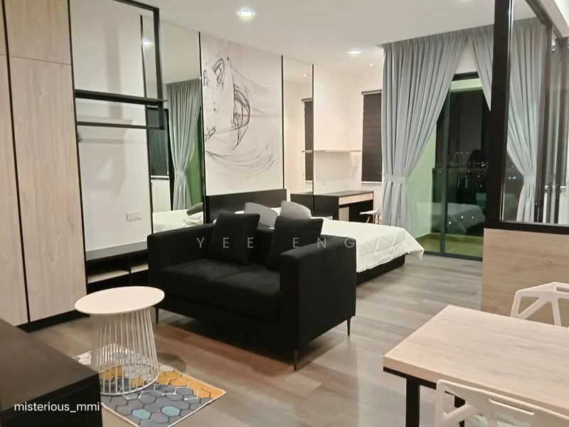
Vista Bangi, BangiVista Bangi — Jalan Reko — for Rent
1 of 5
Price
RM1,900
Bedroom

Studio
Bathroom

1
Room type
Whole unit
Built-up
501 sqft
Get the latest offer for this unit
Home details
Address
Jalan Reko, Jalan Reko, Selangor
Type
Condominium
Title
Commercial under HDA
Tenure
Freehold
Room type
Whole unit
Built-up size
501 sqft
Facilities
Level 11
1
swimming pool
2
kids pool
3
aqua gym
4
gymnasium
5
multipurpose hall
6
jogging track
Ground floor
1
commercial shop lots
2
minimarket
3
restaurant
4
cafeteria
5
24-hour front desk
6
free parking
General
1
24-hour security
2
sauna
3
outdoor fireplace
4
outdoor play area
5
Wi-Fi
Nearby points of interest
- school
Sekolah Menengah Sri Al-Amin Bangi
549 m
- school
Sekolah Rendah Sri Al-Amin
605 m
- school
Sekolah Rendah Kebangsaan Jalan Tiga
667 m
- school
Sekolah Menengah Kebangsaan Jalan Tiga
668 m
- school
SK Jalan Empat
789 m
- school
Sekolah Rendah Islam Wardah Addin
1.0 km
- school
SK Bandar Baru Bangi
1.6 km
- school
SMK Jalan Empat
1.7 km
- school
SMK Bandar Baru Bangi
1.8 km
- school
Sekolah Rendah Islam Ummah An-Nur
1.8 km
1–5 of 10
Crime intelligence
HighIPD Hulu Langat/Kajang · 2023
Total crimes (2023)
1,589
convictions
vs. Selangor avg
+81%
above state median
Most common
Theft vehicle motorcycle
26% of total
Density — crimes per 100k residents
105
per 100k · population ~1.5M
This district
105
Selangor median
58
Coverage area
Kajang, Bangi, Semenyih, Beranang, Balakong
IPD boundaries do not correspond to neighbourhood or administrative boundaries
Crimes by category (2023 convictions)
Theft vehicle motorcycle
418
Theft other
321
Break in
286
Theft vehicle motorcar
159
Causing injury
104
Annual trend (IPD Hulu Langat/Kajang)
2251
2019
2057
2020
1817
2021
1585
2022
1589
2023
District crime index
90 / 100 · 87th percentile in Selangor
Low
Moderate
High
Conviction-based data from PDRM — not reported incidents. Unreported crimes may not be reflected. Police district boundaries differ from administrative mukim boundaries.
Source: Royal Malaysian Police (PDRM) via data.gov.my · CC BY 4.0
Flood risk
Low riskJalan Reko
Based on Sungai Langat, the closest river — its water level and flow, not your exact unit. Every reading below tracks the river flooding, not the building, and your ground may sit higher or lower than the river itself.
Low flood risk to this building
Sungai Langat shows low flood activity, but the building ground sits ≈3 m above it. River flooding reaching this building is very unlikely — Sungai Langat would have to rise about 1 floor first.
Covers river flooding only — flash floods from heavy rain or blocked drains can still affect higher ground. Elevations are approximate (~90 m resolution).
River discharge — water flowing through Sungai Langat, not the building · activity low
Current discharge
N/A
Normal
Mean discharge
N/A
30-day average
Max discharge
N/A
30-day peak
Height above sea level
This building
≈26 m
Sungai Langat
188 m away
≈23 m
Building sits ≈3 m above Sungai Langat
Sungai Langat overflow history — when the river flooded, not the building
River last flooded
No recent floods
Past 2 years
River floods
None recorded
Past 2 years
Monthly river flood risk
Jan
Feb
Mar
Apr
May
Jun
Jul
Aug
Sep
Oct
Nov
Dec
Low
Moderate
High (monsoon)
DID InfoBanjir tracks water levels in real time. Set up alerts at publicinfobanjir.water.gov.my
Source: Jabatan Pengairan dan Saliran (DID) Malaysia · Open-Meteo