New projects
Subsales
Rentals
 MoreMoreMore
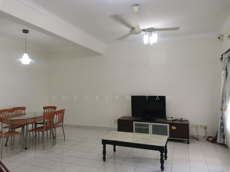
Kota Kemuning, Kota Kemuning, Shah AlamKota Kemuning Township — Kota Kemuning — for Rent
1 of 5
Price
RM1,700
Bedroom

4
Bathroom

3
Room type
Whole unit
Built-up
1,400 sqft
Carpark

2
Get the latest offer for this unit
Home details
Address
jalan anggerik liparis, 40460 Kota Kemuning, Selangor
Type
Terrace
Room type
Whole unit
Built-up size
1,400 sqft
Carparks
2
Facilities
Clubhouse / Sports Facilities
1
18-hole Kota Permai Golf and Country Club
2
Squash courts
3
Fitness centre
4
Swimming pool
5
Tennis courts
6
Community hall (with badminton courts)
Recreational Parks
1
Central Park (25-acre, surrounds 22-acre Central Lake)
2
Wetland Park (nature habitat)
3
Hill Park (with reflexology path, lookout deck, gazebo, walking trail)
4
8km continuous walkway for jogging/cycling
5
Playground
Nearby points of interest
- school
Chinese Taipei School (Kuala Lumpur)
863 m
- school
SJK (C) Khe Beng, Klang
1.3 km
- school
SK Bukit Rimau
1.3 km
- school
SJK (C) Chung Hua Klang 巴生中华华文小学
1.5 km
- school
Sekolah Kebangsaan Kota Kemuning
1.7 km
- school
SJK (T) Ladang Emerald
1.8 km
- school
SRI Al-Thaqafah
2.0 km
- school
Sekolah Menengah Kebangsaan Kota Kemuning
2.1 km
- school
Sekolah Kebangsaan Bukit Kemuning 2
2.2 km
- school
Sekolah Menengah Kebangsaan Taman Sri Muda
2.7 km
1–5 of 10
Crime intelligence
ModerateIPD Shah Alam · 2023
Total crimes (2023)
792
convictions
vs. Selangor avg
−10%
below state median
Most common
Theft vehicle motorcycle
31% of total
Density — crimes per 100k residents
120
per 100k · population ~660,000
This district
120
Selangor median
133
Coverage area
Shah Alam
IPD boundaries do not correspond to neighbourhood or administrative boundaries
Crimes by category (2023 convictions)
Theft vehicle motorcycle
248
Theft other
154
Break in
119
Theft vehicle motorcar
65
Causing injury
54
Annual trend (IPD Shah Alam)
1112
2019
866
2020
853
2021
782
2022
792
2023
District crime index
45 / 100 · 40th percentile in Selangor
Low
Moderate
High
Conviction-based data from PDRM — not reported incidents. Unreported crimes may not be reflected. Police district boundaries differ from administrative mukim boundaries.
Source: Royal Malaysian Police (PDRM) via data.gov.my · CC BY 4.0
Area flood risk
Low riskKota Kemuning
Based on the nearest river monitoring station. This reflects flood risk in the surrounding area, not the specific property.
Current discharge
N/A
Normal
Mean discharge
N/A
30-day average
Max discharge
N/A
30-day peak
Last flooded
No recent floods
Past 2 years
Flood frequency
None recorded
Past 2 years
Monthly flood risk profile
Jan
Feb
Mar
Apr
May
Jun
Jul
Aug
Sep
Oct
Nov
Dec
Low
Moderate
High (monsoon)
DID InfoBanjir tracks water levels in real time. Set up alerts at publicinfobanjir.water.gov.my
Source: Jabatan Pengairan dan Saliran (DID) Malaysia · Open-Meteo