New projects
Subsales
Rentals
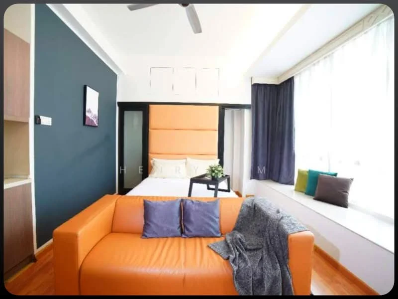
Parkview Service Apartment, KL City CentreParkview Service Apartment — for Rent
1 of 5
Price
RM2,000
Bedroom

1
Bathroom

1
Room type
Single bedroom
Built-up
420 sqft
Get the latest offer for this unit
Home details
Type
Apartment
Title
Strata
Tenure
Freehold
Room type
Single bedroom
Built-up size
420 sqft
Facilities
Rooftop
1
Swimming pool
Ground floor/Common areas
1
Sauna
2
24-hours security
3
BBQ area
4
Parking
5
Business centre
6
Club house
Nearby points of interest
- school
Malaysian Institute of Art - City Campus
742 m
- school
Sekolah Rendah Agama Jalan Raja Muda Musa
818 m
- school
Sekolah Menengah Kebangsaan Convent Bukit Nanas
827 m
- school
SK Convent 2 Bukit Nanas
939 m
- school
SK Pendidikan Khas Kg Baharu
941 m
- school
St. John's International Primary School
1.1 km
- school
SK Kampung Bharu
1.1 km
- school
SMK Puteri Wilayah
1.1 km
- school
SMK St. John
1.1 km
- school
Sekolah Jenis Kebangsaan (Cina) Nan Kai
1.1 km
1–5 of 10
Crime intelligence
HighIPD Dang Wangi · 2023
Total crimes (2023)
993
convictions
vs. Kuala Lumpur avg
+23%
above state median
Most common
Theft other
49% of total
Density — crimes per 100k residents
284
per 100k · population ~350,000
This district
284
Kuala Lumpur median
231
Coverage area
Bukit Bintang, KLCC, Jalan Dang Wangi, Masjid India, Ampang Park, Puduraya
IPD boundaries do not correspond to neighbourhood or administrative boundaries
Crimes by category (2023 convictions)
Theft other
490
Theft vehicle motorcycle
185
Robbery gang unarmed
80
Robbery solo unarmed
79
Break in
59
Annual trend (IPD Dang Wangi)
2914
2019
2040
2020
1411
2021
1128
2022
993
2023
District crime index
90 / 100 · 67th percentile in Kuala Lumpur
Low
Moderate
High
Conviction-based data from PDRM — not reported incidents. Unreported crimes may not be reflected. Police district boundaries differ from administrative mukim boundaries.
Source: Royal Malaysian Police (PDRM) via data.gov.my · CC BY 4.0
Flood risk
Moderate riskBased on Treacher Valley Stream, the closest river — its water level and flow, not your exact unit. Every reading below tracks the river flooding, not the building, and your ground may sit higher or lower than the river itself.
Moderate flood risk to this building
Treacher Valley Stream shows low flood activity, but the building ground sits ≈0 m above it. River flooding could reach this building in an extreme event — Treacher Valley Stream would need to rise about 1 floor.
Covers river flooding only — flash floods from heavy rain or blocked drains can still affect higher ground. Elevations are approximate (~90 m resolution).
River discharge — water flowing through Treacher Valley Stream, not the building · activity low
Current discharge
N/A
Normal
Mean discharge
N/A
30-day average
Max discharge
N/A
30-day peak
Height above sea level
This building
≈38 m
Treacher Valley Stream
48 m away
≈38 m
Building is about level with Treacher Valley Stream
Treacher Valley Stream overflow history — when the river flooded, not the building
River last flooded
No recent floods
Past 2 years
River floods
None recorded
Past 2 years
Monthly river flood risk
Jan
Feb
Mar
Apr
May
Jun
Jul
Aug
Sep
Oct
Nov
Dec
Low
Moderate
High (monsoon)
DID InfoBanjir tracks water levels in real time. Set up alerts at publicinfobanjir.water.gov.my
Source: Jabatan Pengairan dan Saliran (DID) Malaysia · Open-Meteo