New projects
Subsales
Rentals
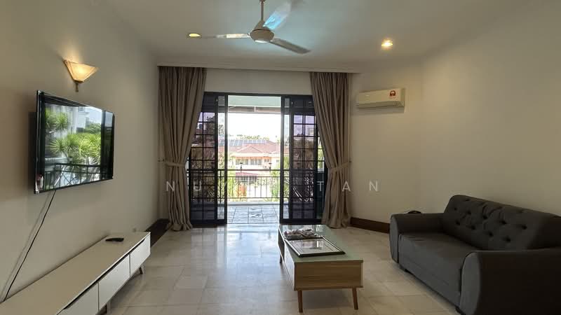
Desa Palma, AmpangDesa Palma — Pesiaran Madge Persiaran Ampang Hilir — for Rent
1 of 5
Price
RM3,800
Bedroom

2 + 1
Bathroom

3
Room type
Whole unit
Built-up
1,300 sqft
Carpark

1
Get the latest offer for this unit
Home details
Address
Pesiaran Madge Persiaran Ampang Hilir, 55000 Pesiaran Madge Persiaran Ampang Hilir, Kuala Lumpur
Type
Condominium
Title
Strata
Tenure
Freehold
Room type
Whole unit
Built-up size
1,300 sqft
Carparks
1
Facilities
All Floors
1
24-hours security
2
Covered parking
3
Clubhouse
4
Mini market
5
Lift service
6
Cafeteria
Nearby points of interest
- school
Nilai International School
1.5 km
- school
Sekolah Menengah Kebangsaan Seri Sepang
2.1 km
- school
SK Salak
2.1 km
- school
SK Agama Integrasi Salak Tinggi
2.1 km
- school
SAM Bandar Baru Salak Tinggi
3.0 km
- school
SRA Bandar Baru Salak Tinggi
3.3 km
- school
Sekolah Kebangsaan Desa Jasmin
3.4 km
- school
PASTI Isbat Al Imtiyaz
3.5 km
- school
Sekolah Rendah Islam Tahfiz Darul Ulum Cawangan Nilai
3.7 km
- school
SK KLIA
3.9 km
1–5 of 10
Crime intelligence
HighIPD Seremban · 2023
Total crimes (2023)
762
convictions
vs. Negeri Sembilan avg
+376%
above state median
Most common
Theft other
31% of total
Density — crimes per 100k residents
107
per 100k · population ~713,000
This district
107
Negeri Sembilan median
22
Coverage area
Seremban, Nilai, Senawang, Rantau, Labu, Lenggeng, Mambau
IPD boundaries do not correspond to neighbourhood or administrative boundaries
Crimes by category (2023 convictions)
Theft other
233
Break in
171
Theft vehicle motorcycle
146
Robbery gang unarmed
54
Causing injury
44
Annual trend (IPD Seremban)
1273
2019
879
2020
684
2021
698
2022
762
2023
District crime index
100 / 100 · 88th percentile in Negeri Sembilan
Low
Moderate
High
Conviction-based data from PDRM — not reported incidents. Unreported crimes may not be reflected. Police district boundaries differ from administrative mukim boundaries.
Source: Royal Malaysian Police (PDRM) via data.gov.my · CC BY 4.0
Flood risk
Low riskPesiaran Madge Persiaran Ampang Hilir
Based on the closest river — its water level and flow, not your exact unit. Every reading below tracks the river flooding, not the building, and your ground may sit higher or lower than the river itself.
Low flood risk to this building
Nearest river shows low flood activity, but the building ground sits ≈27 m above it. River flooding reaching this building is very unlikely — the nearest river would have to rise about 9 floors first.
Covers river flooding only — flash floods from heavy rain or blocked drains can still affect higher ground. Elevations are approximate (~90 m resolution).
River discharge — water flowing through the nearest river, not the building · activity low
Current discharge
N/A
Normal
Mean discharge
N/A
30-day average
Max discharge
N/A
30-day peak
Height above sea level
This building
≈60 m
Nearest river
1.1 km away
≈33 m
Building sits ≈27 m above the nearest river
River overflow history — when the river flooded, not the building
River last flooded
No recent floods
Past 2 years
River floods
None recorded
Past 2 years
Monthly river flood risk
Jan
Feb
Mar
Apr
May
Jun
Jul
Aug
Sep
Oct
Nov
Dec
Low
Moderate
High (monsoon)
DID InfoBanjir tracks water levels in real time. Set up alerts at publicinfobanjir.water.gov.my
Source: Jabatan Pengairan dan Saliran (DID) Malaysia · Open-Meteo