New projects
Subsales
Rentals
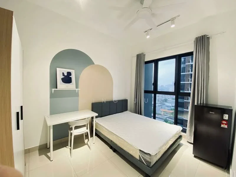
Trion 2 @ KL, Chan Sow Lin, CherasTrion 2 — for Rent
1 of 5
Price
RM1,499
Bedroom

Studio
Bathroom

1
Room type
Whole unit
Built-up
250 sqft
Carpark

1
Get the latest offer for this unit
Home details
Type
Apartment
Tenure
Freehold
Room type
Whole unit
Built-up size
250 sqft
Carparks
1
Nearby points of interest
- school
Sekolah Jenis Kebangsaan (Cina) Sam Yoke
351 m
- school
SJK (C) Chung Kwo
942 m
- school
SMK (P) Pudu
944 m
- school
Sekolah Menengah Kebangsaan Dato' Onn
1.0 km
- school
SJK (T) Jalan San Peng
1.1 km
- school
The Alice Smith School (Primary Campus)
1.2 km
- school
Sekolah Rendah Agama Aslahiyah
1.3 km
- school
Sekolah Kebangsaan Pendidikan Khas Jalan Peel
1.3 km
- school
Sekolah Menengah Tsun Jin
1.3 km
- school
Sekolah Kebangsaan Jalan Bellamy
1.3 km
1–5 of 10
Crime intelligence
LowIPD Cheras · 2023
Total crimes (2023)
758
convictions
vs. Kuala Lumpur avg
−6%
below state median
Most common
Theft vehicle motorcycle
27% of total
Density — crimes per 100k residents
168
per 100k · population ~450,000
This district
168
Kuala Lumpur median
180
Coverage area
Cheras, Pudu, Salak Selatan, Sungai Besi, Bukit Jalil, Desa Petaling
IPD boundaries do not correspond to neighbourhood or administrative boundaries
Crimes by category (2023 convictions)
Theft vehicle motorcycle
203
Theft other
191
Theft vehicle motorcar
124
Break in
76
Causing injury
51
Annual trend (IPD Cheras)
1635
2019
1295
2020
1058
2021
849
2022
758
2023
District crime index
69 / 100 · 17th percentile in Kuala Lumpur
Low
Moderate
High
Conviction-based data from PDRM — not reported incidents. Unreported crimes may not be reflected. Police district boundaries differ from administrative mukim boundaries.
Source: Royal Malaysian Police (PDRM) via data.gov.my · CC BY 4.0
Flood risk
Low riskBased on the closest river — its water level and flow, not your exact unit. Every reading below tracks the river flooding, not the building, and your ground may sit higher or lower than the river itself.
Low flood risk to this building
Nearest river shows low flood activity, but the building ground sits ≈2 m above it. River flooding reaching this building is very unlikely — the nearest river would have to rise about 1 floor first.
Covers river flooding only — flash floods from heavy rain or blocked drains can still affect higher ground. Elevations are approximate (~90 m resolution).
River discharge — water flowing through the nearest river, not the building · activity low
Current discharge
N/A
Normal
Mean discharge
N/A
30-day average
Max discharge
N/A
30-day peak
Height above sea level
This building
≈41 m
Nearest river
421 m away
≈39 m
Building is about level with the nearest river
River overflow history — when the river flooded, not the building
River last flooded
No recent floods
Past 2 years
River floods
None recorded
Past 2 years
Monthly river flood risk
Jan
Feb
Mar
Apr
May
Jun
Jul
Aug
Sep
Oct
Nov
Dec
Low
Moderate
High (monsoon)
DID InfoBanjir tracks water levels in real time. Set up alerts at publicinfobanjir.water.gov.my
Source: Jabatan Pengairan dan Saliran (DID) Malaysia · Open-Meteo