New projects
Subsales
Rentals
 MoreMoreMore
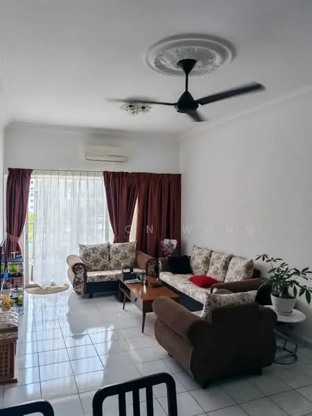
Menara Menjalara, Bandar MenjalaraMenara Menjalara — - Jalan 1/62D — for Sale
1 of 5
Price
RM420,000
Bedroom

3
Bathroom

2
Built-up
1,076 sqft
Carpark

1
Get the latest offer for this unit
Home details
Price per sqft
RM390.33 psf
Address
- Jalan 1/62D, - Jalan 1/62D, Kuala Lumpur
Built-up size
1,076 sqft
Carparks
1
Furnished
Yes
Title
Strata
Tenure
Freehold
Type
Condominium
Bumi reserved
No
Facilities
Ground Floor
1
Parking bays
2
24-hour security
3
Tennis court
4
Swimming pool
5
Playground
6
Cafeteria
Nearby points of interest
- school
The Early Years Center
434 m
- school
SWIMAX
447 m
- school
Seri Stamford College
490 m
- school
Sekolah Menengah Kebangsaan Agama Kuala Lumpur
793 m
- school
Sekolah Menengah Kebangsaan Menjalara
1.0 km
- school
Dancesteps Ballet
1.0 km
- school
Sekolah Kebangsaan Menjalara
1.2 km
- school
Sekolah Kebangsaan Sri Damansara 3
1.3 km
- school
Kolej Tingkatan Enam Desa Mahkota
1.3 km
- school
Sekolah Jenis Kebangsaan (Cina) Kepong 3
1.4 km
1–5 of 10
Market intelligence
34 transactionsMENARA MENJALARA · Kuala Lumpur
RM 390.33 psf
This listing
+6.2%vs project median
RM 347
RM 368 (median)
RM 483
Cheapest in project
Most expensive
Median PSF
367.53
RM per sq.ft
Median price
388K
24-month median
PSF trend
-3.7%
12-month change
PSF by floor level
L1-5
RM367.53
(5)
L6-10
RM463.58
(10)
L11-15
RM360.46
(16)
L16-20
RM418.06
(3)
Source: NAPIC (National Property Information Centre) · Kuala Lumpur
Crime intelligence
HighIPD Sentul · 2023
Total crimes (2023)
1,101
convictions
vs. Kuala Lumpur avg
+36%
above state median
Most common
Theft other
28% of total
Density — crimes per 100k residents
124
per 100k · population ~888,000
This district
124
Kuala Lumpur median
91
Coverage area
Sentul, Wangsa Maju, Setapak, Kepong, Jinjang, Setiawangsa, Danau Kota
IPD boundaries do not correspond to neighbourhood or administrative boundaries
Crimes by category (2023 convictions)
Theft other
303
Theft vehicle motorcycle
269
Theft vehicle motorcar
159
Break in
125
Causing injury
81
Annual trend (IPD Sentul)
2515
2019
1849
2020
1545
2021
1164
2022
1101
2023
District crime index
100 / 100 · 83rd percentile in Kuala Lumpur
Low
Moderate
High
Conviction-based data from PDRM — not reported incidents. Unreported crimes may not be reflected. Police district boundaries differ from administrative mukim boundaries.
Source: Royal Malaysian Police (PDRM) via data.gov.my · CC BY 4.0
Area flood risk
Low risk- Jalan 1/62D
Based on the nearest river monitoring station. This reflects flood risk in the surrounding area, not the specific property.
Current discharge
N/A
Normal
Mean discharge
N/A
30-day average
Max discharge
N/A
30-day peak
Last flooded
No recent floods
Past 2 years
Flood frequency
None recorded
Past 2 years
Monthly flood risk profile
Jan
Feb
Mar
Apr
May
Jun
Jul
Aug
Sep
Oct
Nov
Dec
Low
Moderate
High (monsoon)
DID InfoBanjir tracks water levels in real time. Set up alerts at publicinfobanjir.water.gov.my
Source: Jabatan Pengairan dan Saliran (DID) Malaysia · Open-Meteo