New projects
Subsales
Rentals
New launch
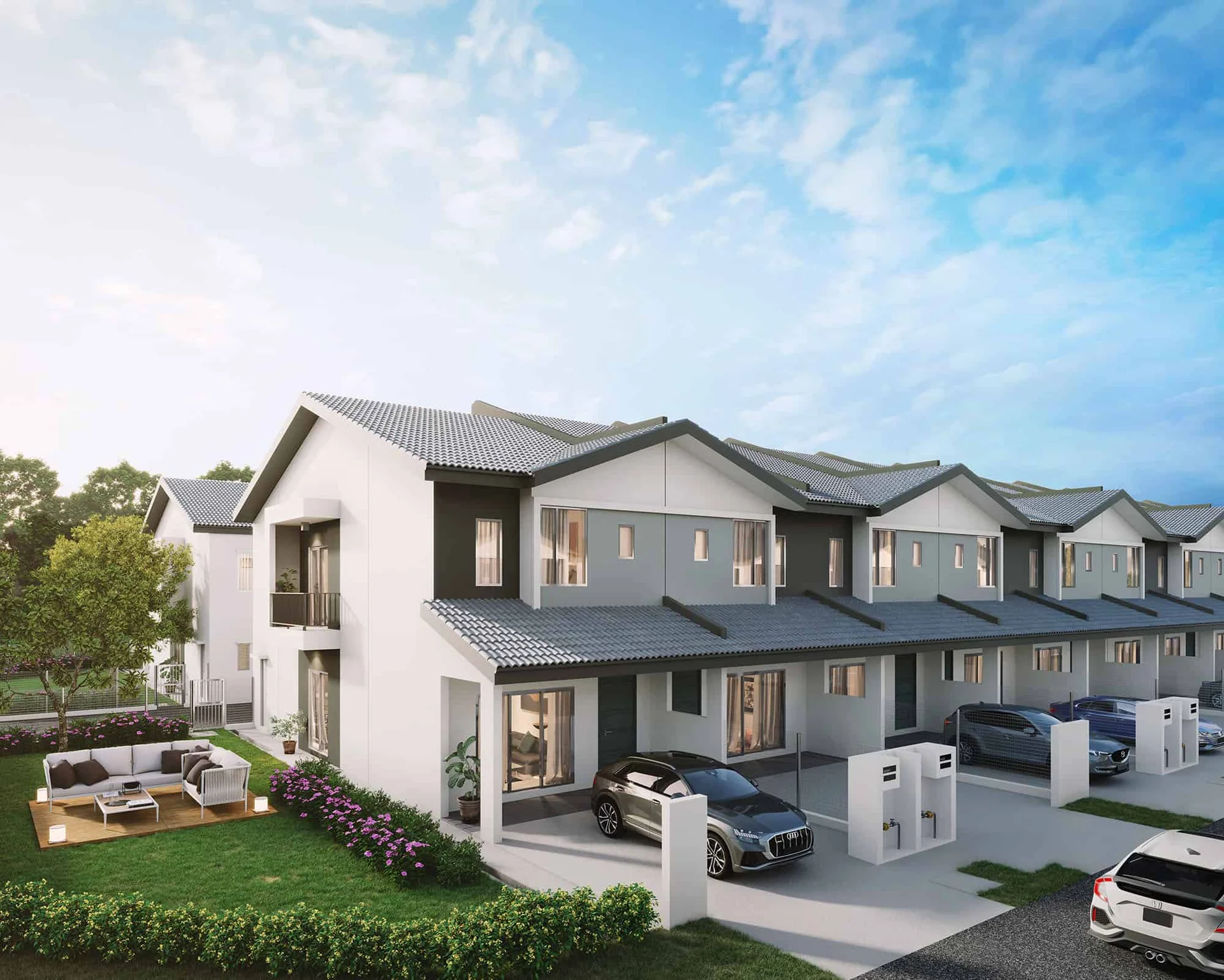
Allamanda @ Meridin East (Fasa 4A1)Pasir Gudang — for Sale
Price Range
SPA Price Before Rebate
RM587,000 - RM825,000
Bedroom

4
Bathroom

3
Built-up
1,676 sqft
Get the latest offer for this project
Home details
Developer
Mah Sing
Price per sqft
RM350 - RM492 psf
Title
Residential
Tenure
Freehold
Type
Terrace
Layout size
1,676 sqft
Unit layouts
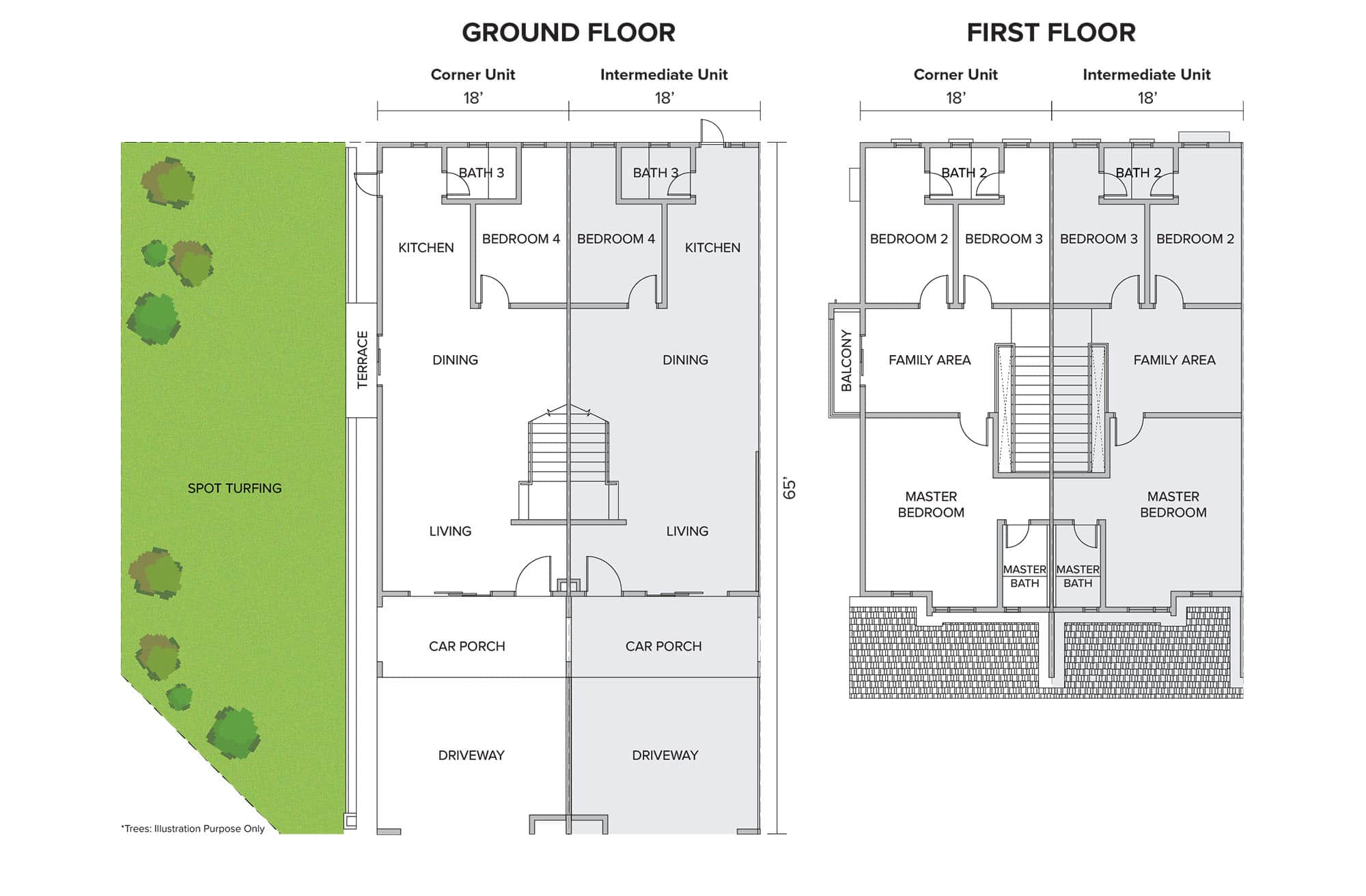
Unit type
Type Corner (18'x65')
Built-up size
1,676 sqft
Bedrooms
4
Bathrooms
3
Nearby points of interest
- school
SK Cahaya Baru
232 m
- school
SK Cahaya Baru
245 m
- school
Sekolah Agama Dato' Hj Abdul Rahman Ahmad
337 m
- school
Sekolah Agama Dato' Hj Abdul Rahman Ahmad
339 m
- school
Sekolah Kebangsaan Kopok
1.5 km
- school
SMK Taman Scientex
2.6 km
- school
SK Taman Scientex
2.6 km
- school
SMK Kota Masai
3.3 km
- school
SJK (C) Ladang Grisek 新廊华文小学
3.8 km
- school
Sekolah Seni Johor Bahru
3.8 km
1–5 of 10
Market intelligence
9 transactionsMERIDIN EAST · Johor Bahru
RM 350.24 psf
This listing
-2.2%vs project median
RM 295
RM 358 (median)
RM 383
Cheapest in project
Most expensive
Median PSF
358.00
RM per sq.ft
Median price
605K
24-month median
PSF trend
+14.0%
12-month change
All transactions (last 3 years) · 200 total
| Price | Date | Built-up | PSF |
|---|---|---|---|
| RM800,000 | November 2025 | 2088 sqft | RM383.10 |
| RM605,000 | November 2024 | 1690 sqft | RM358.00 |
| RM605,000 | November 2024 | 1690 sqft | RM358.00 |
| RM605,000 | September 2024 | 1690 sqft | RM358.00 |
| RM500,000 | September 2024 | 1593 sqft | RM313.86 |
1–5 of 200
3-year growth
+25.3%
1-year growth
+14.0%
Median PSF (RM/sq ft)
Projects in Plentong, Johor Bahru · 9 projects
TMN SCIENTEX
94 txns
RM381.82 psf • Freehold • +4.2%
BANDAR LAYANGKASA
56 txns
RM322.39 psf • +4.2%
TMN SRI PULAI PERDANA
41 txns
RM371.61 psf • Freehold • +26.1%
TMN CAHAYA MASAI
28 txns
RM392.54 psf • +15.8%
BANDAR BISTARI PERDANA
21 txns
RM341.27 psf • Freehold • -20.3%
1–5 of 9
Source: NAPIC (National Property Information Centre) · Johor Bahru
Crime intelligence
HighIPD Seri Alam · 2023
Total crimes (2023)
871
convictions
vs. Johor avg
+177%
above state median
Most common
Theft vehicle motorcycle
31% of total
Density — crimes per 100k residents
163
per 100k · population ~535,000
This district
163
Johor median
59
Coverage area
Pasir Gudang, Masai, Seri Alam, Permas Jaya
IPD boundaries do not correspond to neighbourhood or administrative boundaries
Crimes by category (2023 convictions)
Theft vehicle motorcycle
268
Theft other
196
Break in
133
Theft vehicle motorcar
87
Robbery gang unarmed
59
Annual trend (IPD Seri Alam)
1490
2019
1315
2020
889
2021
783
2022
871
2023
District crime index
79 / 100 · 86th percentile in Johor
Low
Moderate
High
Conviction-based data from PDRM — not reported incidents. Unreported crimes may not be reflected. Police district boundaries differ from administrative mukim boundaries.
Source: Royal Malaysian Police (PDRM) via data.gov.my · CC BY 4.0
Flood risk
Low riskPasir Gudang
Based on Sungai Serai, the closest river — its water level and flow, not your exact unit. Every reading below tracks the river flooding, not the building, and your ground may sit higher or lower than the river itself.
Low flood risk to this building
Sungai Serai shows low flood activity, but the building ground sits ≈16 m above it. River flooding reaching this building is very unlikely — Sungai Serai would have to rise about 5 floors first.
Covers river flooding only — flash floods from heavy rain or blocked drains can still affect higher ground. Elevations are approximate (~90 m resolution).
River discharge — water flowing through Sungai Serai, not the building · activity low
Current discharge
N/A
Normal
Mean discharge
N/A
30-day average
Max discharge
N/A
30-day peak
Height above sea level
This building
≈29 m
Sungai Serai
461 m away
≈13 m
Building sits ≈16 m above Sungai Serai
Sungai Serai overflow history — when the river flooded, not the building
River last flooded
No recent floods
Past 2 years
River floods
None recorded
Past 2 years
Monthly river flood risk
Jan
Feb
Mar
Apr
May
Jun
Jul
Aug
Sep
Oct
Nov
Dec
Low
Moderate
High (monsoon)
DID InfoBanjir tracks water levels in real time. Set up alerts at publicinfobanjir.water.gov.my
Source: Jabatan Pengairan dan Saliran (DID) Malaysia · Open-Meteo
Frequently asked questions
How much does Allamanda @ Meridin East (Fasa 4A1) cost?
Units at Allamanda @ Meridin East (Fasa 4A1) are priced from RM587,000 up to RM825,000.
What is the price per square foot at Allamanda @ Meridin East (Fasa 4A1)?
Based on 9 recent verified transactions nearby, the median price is RM358.00 per sq ft.
Is Allamanda @ Meridin East (Fasa 4A1) at risk of flooding?
Allamanda @ Meridin East (Fasa 4A1) sits in a low flood risk area.
How safe is the area around Allamanda @ Meridin East (Fasa 4A1)?
The Seri Alam area has a high crime level based on the latest police statistics.
What is the tenure of Allamanda @ Meridin East (Fasa 4A1)?
Allamanda @ Meridin East (Fasa 4A1) is a freehold development.
Subsale listings
0 result
Rental listings
0 result